Information about Weather MapsThe information displayed on a weather map is used to illustrate processes that are continuously occurring in the atmosphere. The majority of these processes are not visible to the naked eye, so symbols are used to represent their location on a map. The symbols are designed to convey a large amount of weather information on a limited amount of map space. Weather maps illustrate current weather such as cloud coverage, precipitation, thunderstorms, high and low pressure systems, wind speed and wind direction. Fronts are also illustrated on weather maps. Fronts are boundaries between warm and cold air masses. A great deal of information can be gathered from a weather map by understanding the various symbols used to describe the weather conditions. Spatial Patterns of Meteorological VariablesMeteorological variables, such as temperature, dew point, and barometric (atmospheric) pressure, have spatial distributions which can be displayed on a map. The use of isolines is commonly used for highlighting spatial patterns of specific variables. An isoline is a line of constant value: isotherms are lines of constant temperature; isodrosotherms are lines of constant dew point; and isobars are lines of constant barometric pressure. There are several generalizations that can be made about isolines:
Air Masses Influencing Weather in North AmericaAn air mass is a large body of air with relatively uniform temperature and humidity. An air mass forms over large bodies of land or water and take on the characteristics of that surface. Air masses that form over land are referred to as continental while air masses forming over large water bodies are referred to as maritime, reflecting the high moisture continent found in them. Air masses are also classified by their temperature characteristics. Depending on where they form, an air mass may be described as equatorial, tropical, polar, or arctic. When two unlike air masses meet, the boundary between the them is called a front. A cold front is when cold air overtakes an area of warmer air, and a warm front is used to describe a warm air mass moving into an area of cooler air. Weather events such as cloud formation, precipitation, thunderstorms, and wind generally develop near a frontal boundary. Pressure Systems and WindThe air that makes up the atmosphere is not evenly distributed around the earth. An area that has a higher concentration of air is referred to as an area of high pressure, while an area with a lower concentration of air is referred to as an area of low pressure. On a weather map, pressure systems are labeled with an H for high pressure and an L for low pressure. Air moves from areas of high pressure to areas of low pressure creating wind. This is because the atmosphere constantly strives to obtain an equilibrium, or equal air pressure, around the earth. Air moves clockwise around a high pressure system and counter-clockwise around a low pressure system. Therefore wind speed and direction can be estimated by knowing the location of high and low pressure systems on a weather map. The weather map below illustrates high and low pressure systems as well as frontal boundaries.
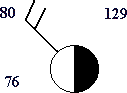
Map SymbolsSymbols are used on weather maps to illustrate where weather phenomenon are occurring. These symbols represent wind speed and direction, the various types of precipitation, and the percent of cloud cover. A weather station is depicted on a map by a circle. Numbers around the station symbol indicate the temperature, dew point, and pressure (see the example below). The value for temperature is located on the upper left side of the station symbol, dew point on the lower left. The value for pressure is located to the upper right of the station symbol. The value represents the last three digits of the observed pressure. If the value is greater than 500, the initial 9 is missing, if the value is less than 500 the initial 10 is missing. The pressure is determined by placing the 9 or 10 in front of the reported value and dividing by 10.For example:
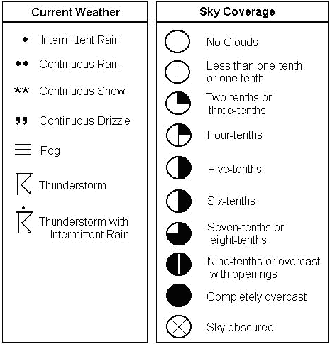
The figures below show map symbols wind, sky coverage, and precipitation. 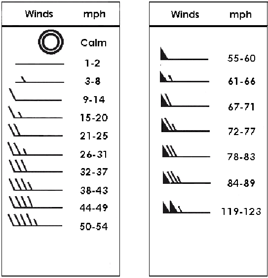
 Activity Questions
|

 The
amount of the circle filled in represents the amount of cloud cover at
that location. Wind speed is shown on a weather map by various symbols.
Calm conditions is depicted by two open circles, one inside the other.
Winds 1-2 mph is depicted by a straight line and wind speeds above that
are depicted by one or more barbs and/or triangles attached to a straight
line. These symbols are referred to as wind barbs. The wind direction is
indicated by the flat end of the wind barb, which will point into the station.
This figure depicts a weather station reporting five-tenths sky coverage
and winds blowing from the northwest at 21-25 mph. This symbol also shows
a temperature of 86 degrees, a dew point of 76, and a pressure of 1012.9.
The
amount of the circle filled in represents the amount of cloud cover at
that location. Wind speed is shown on a weather map by various symbols.
Calm conditions is depicted by two open circles, one inside the other.
Winds 1-2 mph is depicted by a straight line and wind speeds above that
are depicted by one or more barbs and/or triangles attached to a straight
line. These symbols are referred to as wind barbs. The wind direction is
indicated by the flat end of the wind barb, which will point into the station.
This figure depicts a weather station reporting five-tenths sky coverage
and winds blowing from the northwest at 21-25 mph. This symbol also shows
a temperature of 86 degrees, a dew point of 76, and a pressure of 1012.9.